Maricopa, Pinal counties under excessive heat warning through July 9
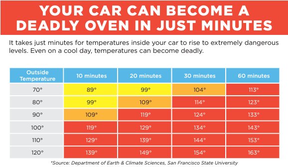
(Courtesy Arizona Department of Health Services)
The National Weather Service expects temperatures to approach 117 degrees over the next several days, and state health officials have placed Maricopa and Pinal counties under an excessive heat warning.
The Arizona Department of Health Services advises county residents to do outdoor activities in the early morning or evening hours and stay hydrated.
National Weather Service officials said “dangerously high temperatures up to 117°F are expected with the potential to cause life-threatening illnesses or even death.”
You must be a member to read this story.
Join our family of readers starting at $5 for your first month and support local, unbiased journalism.
Click here to see your options for becoming a subscriber.
Register to comment
Click here create a free account for posting comments.
Note that free accounts do not include access to premium content on this site.
I am anchor
WEATHER
Maricopa, Pinal counties under excessive heat warning through July 9
(Courtesy Arizona Department of Health Services)
Posted
INDEPENDENT NEWSMEDIA
The National Weather Service expects temperatures to approach 117 degrees over the next several days, and state health officials have placed Maricopa and Pinal counties under an excessive heat warning.
The Arizona Department of Health Services advises county residents to do outdoor activities in the early morning or evening hours and stay hydrated.
National Weather Service officials said “dangerously high temperatures up to 117°F are expected with the potential to cause life-threatening illnesses or even death.”
In addition, temperatures inside cars can skyrocket to life-threatening levels within minutes, posing serious risks even on cooler days, health officials warned in a release.
“Never leave children or pets unattended in a car. Always double-check to ensure everyone is out of the vehicle before leaving,” they said.
We’d like to invite our readers to submit their civil comments on this issue. Email AZOpinions@iniusa.org.



Comments
No comments on this item Please log in to comment by clicking here